Digital Aerial Surveys for Offshore Wind Developments in Irish Waters
In a partnership to support sustainable offshore wind development, APEM Group and Flotation Energy have completed a series of 24...

Through our network of specialist brands and strong presence in Australia and Europe, APEM Group brings decades of expertise to environmental impact assessments for wind farm developments. For over two decades, we have been at the forefront of guiding projects in both regions, transferring knowledge, innovation, and best practices across continents.
In addition to extensive onshore wind impact assessments delivered by APEM Group companies across Australia and the UK, our leadership in environmental approvals has expanded into offshore wind in Australia. This began with Southerly Ten’s pioneering Star of the South project, the first proposed offshore wind project in Australian waters.
The project’s EIA was led by RPS Australia, who recognised that APEM Group, particularly when leveraging the in-house expertise of long-standing wind farm specialists Biosis, offers robust technical capability in offshore ecology. Coupled with APEM Group’s global specialist marine wildlife survey team, which uses digital aerial surveys with LiDAR (Light Detection and Ranging), RPS was able to bring the latest technologies and expertise to Australian projects. These services enabled the Group to provide an effective route for collecting data to meet Australia’s state and federal regulatory requirements, ensuring the environmental approvals process delivers greater certainty in a more efficient manner.
Being front-runners in boat-based and digital aerial surveys in Gippsland has delivered significant benefits to APEM Group and our clients, providing critical experience in collecting robust baseline marine wildlife and bird behaviour data for project needs. These datasets underpin the confidence regulators require to inform subsequent environmental impact assessments for offshore wind proposals in Gippsland and other declared offshore wind areas. Importantly, this data can be used for comparison in multi-year studies to understand the influence and effects of offshore wind on marine wildlife and seabirds.
Learn more about the Star of the South offshore wind project’s marine wildlife and seabird data capture methods below.

Star of the South’s proposed location off the south coast of Gippsland, Southeast Australia has the potential to supply up to 20% of the State of Victoria’s electricity needs as well as creating jobs and investment in the local economy.
Offshore wind facility design and engineering depend on site-specific conditions, including the impact to marine wildlife and seabirds. APEM Group has been collecting, analysing and interpreting marine wildlife and seabird data for use in environmental impact assessments (EIA) since 2009, supporting the preliminary stages of offshore wind development in Europe.
For Australia’s first ever proposed offshore wind farm APEM and Biosis (part of APEM Group) were contracted by RPS, the lead EIA consultancy for Star of the South, to provide marine wildlife and seabird surveys for this project in the Bass Strait, off the Victorian coast of southeast Australia.


An important part of the environmental approvals process is accurately determining bird collision risk with offshore wind turbines.
The Biosis collision risk model (CRM), developed in the early 2000s to measure the risk of onshore wind turbine collisions with birds, is now the dominant industry standard in Australia, especially for onshore wind farm avian impact assessments. The model was adapted for the Star of the South project to suit the offshore environment and identify potential risks to seabirds within the Gippsland declared offshore wind area.
Accurately determining bird collision risk from turbines within a wind farm depends on two key factors: capturing flying bird density data and bird flight height data for the area of interest over a sufficient period to account for seasonal and inter-annual variations. This data is then applied to the collision risk model to estimate how many birds may be subject to mortality from turbine strikes; a critical component of impact assessments for both onshore and offshore wind farm approvals.
The services supplied by APEM and Biosis for the Star of the South included:

APEM’s ultra-high resolution digital aerial surveys are delivered throughout the world.
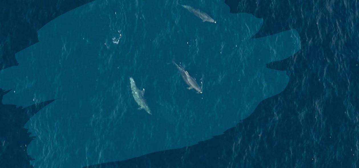
The programme of digital aerial surveys that were undertaken for the Star of the South lasted for 26 months recording birds, marine mammals and any other receptors such as boats to characterise the baseline environment for the project’s EIA. The key focus was on birds, recording species type, abundance, density, distribution and flight heights, with surveys flown at an industry leading 1.5cm ground sampling distance (GSD) using a grid methodology.
APEM’s ultra-high resolution digital aerial stills methods (not video) were used to capture a permanent record, which can be effortlessly reviewed again later if required and supports robust quality control procedures that we perform at every stage of the image collection and analysis process.
The Star of the South project was a trailblazer for another reason. As well as using ultra-high resolution aerial digital surveys, APEM combined LiDAR technology, a technique that APEM pioneered.
Combined LiDAR surveys were first developed and trialled in 2018 at the Race Bank and Hornsea One offshore wind farms in the UK. Our experience with all forms of remote sensing practices led our technical scientists to consider how surveys over land could be adapted and applied to the marine environment.
LiDAR was added in the second year of survey programme to aid the collection of accurate flight heights. The use of LiDAR ensured that in the second year of our survey effort we were able to provide accurate flight heights (within 1 metre) for every flying bird recorded, which is a critical piece of input data for collision risk modelling.
This method is currently being used by a handful of developers around the world; ensuring robust flight height data is modelled for potential collision risk to birds during operation, and mitigation methods can be put in place during the design phase.
APEM’s global best practice survey design ensures we provide the highest quality data and advice that delivers exactly what our clients require to meet the needs of the regulators.
Alongside cutting‑edge aerial and LiDAR methods, the Star of the South project also employed traditional boat‑based marine wildlife surveys. Expert ecologists conducted extensive transect work from vessels using binoculars to visually identify seabirds and marine mammals, record behaviour, and estimate flight heights.
Learn more about our toolbox survey approach:

“A first of its kind survey in Australia was never going to be easy, combined with some of the world’s toughest lockdowns for Covid 19. Logistics were often challenging, managing surveys on the other side of the world, and often with late night calls to talk through the latest Covid restrictions. APEM were able to mobilise survey equipment and technicians into a new, unfamiliar market and location and complete all scheduled surveys.
APEM worked with local ornithology experts to ensure QA/QC was completed to a very high standard. We now have a robust data set, critical for the project impact assessment.”
Get hand-picked content from our subject matter specialists. Sign up to receive relevant updates, resources, and ideas that help you and your organisation.
We're here to help. Whether you're looking for tailored insights, support with a project, or just want to explore how we can work together, contact our team today.
In a partnership to support sustainable offshore wind development, APEM Group and Flotation Energy have completed a series of 24...

APEM Ltd, part of APEM Group, was commissioned by Natural England, via the Monitoring, evaluation and learning (MEL) facility managed...

Natural England contracted APEM Group to determine the spatial extent and breeding population size of the Lesser Black-backed Gull (Larus...