LiDAR Surveys for Offshore Wind Projects in Australia – Animation
Discover how LiDAR technology is transforming environmental monitoring for offshore wind projects in Australia, delivering precise data to support sustainable...


Biosis, part of APEM Group and one of Australia’s leading specialist ecology companies working in the wind farm sector, delivered a presentation at the Clean Energy Council’s Wind Summit (2026) on its use of thermal cameras and machine learning technology to better understand microbat flight activity at wind farm sites.
The innovative solution is already showing promise in providing critically needed insights into flight heights and behaviour of microbats, helping ecologists guide wind farm design and bird and bat management plans.
It is widely understood that wind turbines can pose a significant risk to bat species around the world. In Europe and some parts of North America, wind farms are required to curtail turbine operation during seasonal activity to protect microbats. In some cases, sensors are also attached to turbines to rapidly stop blade rotation and avoid collisions in real time (known as triggered smart curtailment).
Australia is home to more than sixty species of microbats, many of which are protected. As a result, mitigation measures are becoming an increasing requirement for planning approvals.
However, quantifying the level of risk wind turbines pose to bats at Australian sites has been challenging. Ecologists have struggled to advise developers on collision risk due to the absence of site- and species-specific data on Australian microbats.
A promising new data capture method is currently being trialled at four proposed wind farm sites in New South Wales (NSW), following successful trials using thermal cameras for bat detection at turbines in the United States and Europe. While still in its early stages of review, the approach could prove highly valuable by combining two technologies to illuminate the otherwise invisible flight paths of these insectivorous nocturnal species.
Thermal imaging technology allows microbat flights to be visualised, bringing their nocturnal activity into view for the first time. Biosis ecologists pair this with ultrasonic audio recordings to understand species-specific flight heights.
Biosis Senior Zoologist in Bat Ecology, Felicity Williams, who has extensive experience conducting bat utilisation surveys at wind farm sites, is managing the new data capture method. She explains that while traditional survey methods have been useful, they have not provided sufficient data for predictive risk modelling.

Biosis Emma Heath and Wes Hart installing thermal cameras
“Traditionally, we have recorded bat calls using audio detectors, which can help identify threatened species, but they do not tell us the height bats are flying at, which is critical for measuring collision risk with turbines. Another limitation is the lack of visual evidence – we cannot see their flight paths, so we don’t know if calls are coming from a single bat or multiple bats. The new technique using thermal imaging is bringing the microbat night scene to life, enabling us to see, hear and count them like never before.”
Biosis has partnered with American-based technology company Wildlife Imaging Systems (WIS) to enable tracking of bats around wind infrastructure. Wildlife Imaging Systems has developed machine learning software that uses pattern recognition to quickly distinguish bat movements from other flying wildlife such as birds. This enables Williams and her team to identify specific Australian bat species by matching detections to time-specific echolocation audio recordings.
By combining these datasets, the team can reveal species-specific behavioural patterns, including not only flight height but also peak activity periods such as feeding.
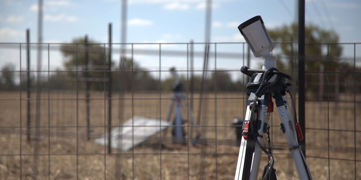
Biosis 3D Stereo thermal camera setup scaled aspect ratio 1200 600
Brogan Morton explains how the software improves data processing efficiency:
“Our software processes two thermal video streams into detections and tracks, synchronises them, and performs camera-to-camera calibration to estimate three-dimensional (3D) location without the need for expensive synchronised thermal cameras or complex field calibration methods. This allows data to be collected using field-ready security cameras that can be deployed remotely with solar panels and batteries. Our patent-pending auto-calibration technology enables 3D position estimation using only bat and bird detections captured during surveys.”
The ability to study microbat behaviour before wind farm construction is particularly significant. As Morton explains, 3D flight height measurement will have global relevance:
“We typically work at sites where turbines are already operational, focusing on reducing fatalities. We are particularly interested in the Biosis research, as understanding flight height before construction will help inform collision risk assessment and wind farm design worldwide.”
Biosis expects that, over a 12-month period, the data will provide essential insights into collision risk for its Australian clients.
Biosis is an Australian leader in collision risk modelling, having co-created the current standard used across the renewable energy industry for avian (bird) collision risk assessment. While this model has been used for decades, there is not yet a widely accepted bat collision risk model, due to the complexity of bat behaviour and the challenges associated with capturing reliable night-time data.
Without sufficient evidence to determine site-specific risk, regulators often adopt a precautionary approach. This has led to mitigation measures such as blanket curtailment, where turbines are stopped for extended periods each evening, regardless of actual bat activity.
This approach can result in significant revenue loss for energy producers, particularly during peak demand periods such as early evening. There are also ecological implications: without robust, site-specific data, ecologists cannot provide targeted mitigation strategies that both safeguard biodiversity and maximise renewable energy generation.
Get hand-picked content from our subject matter specialists. Sign up to receive relevant updates, resources, and ideas that help you and your organisation.
We're here to help. Whether you're looking for tailored insights, support with a project, or just want to explore how we can work together, contact our team today.
Discover how LiDAR technology is transforming environmental monitoring for offshore wind projects in Australia, delivering precise data to support sustainable...
Understanding the environmental impact of offshore wind farms is critical for sustainable offshore energy development in Australia.
A Growing Sector Facing Complex Realities Across Australia and the wider Asia–Pacific region, offshore wind is shifting from ambition to...